


Flight Data Investigator
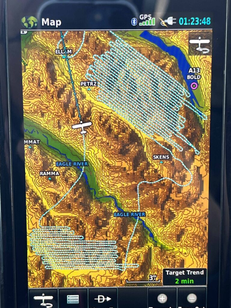
Flight Data Investigator (FDI) is a piece of software designed by Matt, and built by a geospatial professional. FDI is a tool for managing thousands of waypoints. The waypoints represent the location of a unique object. For my purposes, these “objects” are radio collared animals, in your case it could be anything. The data represented on the map is then searchable by any feature listed in the custom built database. Additionally, any geotagged images will appear on the map at the location they were captured for immediate review. This software has completely reshaped efficiency as it relates to these complex data sets.
searchable database of gps waypoints
Searchable waypoints can be added to the database at any time by simply typing them in. Major changes to the database structure and content are done by Blue Ice Aviation Technology. There is no limit to the number of columns and rows that can be added to the database.
flight data investigator flyer request

Flight Data Investigator
Flight Data Investigator (FDI) is a piece of software designed by Matt, and built by a geospatial professional. FDI is a tool for managing thousands of waypoints. The waypoints represent the location of a unique object. For my purposes, these “objects” are radio collared animals, in your case it could be anything. The data represented on the map is then searchable by any feature listed in the custom built database. Additionally, any geotagged images will appear on the map at the location they were captured for immediate review. This software has completely reshaped efficiency as it relates to these complex data sets.
searchable database of gps waypoints
Searchable waypoints can be added to the database at any time by simply typing them in. Major changes to the database structure and content are done by Blue Ice Aviation Technology. There is no limit to the number of columns and rows that can be added to the database.
flight data investigator flyer request
Photogrammetry
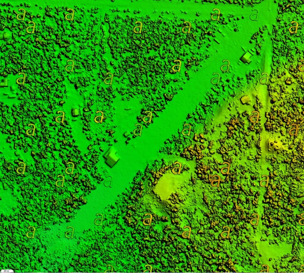
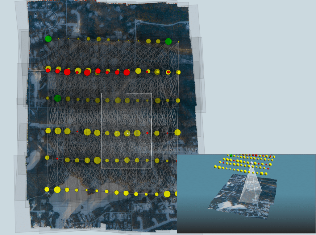
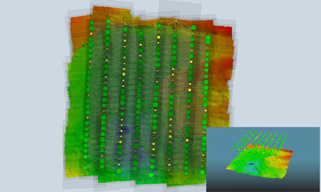
Aviatrix software creates a custom flight plan of any geographic zone. The altitude flown depends on desired image resolution for the project. The software selects the camera firing points and controls the camera while the flight plan is flown. At the end of the flight thousands of images have been captured on RGB and/or NIR cameras.The result, after the post processing has been completed, is a 3D model of the topography.
Photogrammetry has been used since WWII. The difference today is that software can digitally stitch together the thousands of images to create the finished product overnight. The process is known as Structure from Motion (SFM) and is considered a “poor man’s lidar”.
projects completed:
- 3D mapping of Hawkins Island
- 3D mapping of Green Island
- Multiple 3D mappings of Eklutna Glacier
- Church Mountain Sheep Habitat
- Vegetation sampling Alphabet hills
- Clam Gulch clam beds
- 3D mapping Chugach fault line

wildlife management & research
experienced fixed wing utility pilot
The Super Cub and the Cessna 185 are the ultimate tools for economical game surveillance. No other certified fixed-wing aircraft can operate as effectively, with excellent visibility, efficiency, and flexibility. Blue Ice Aviation has worked on hundreds of projects including: moose, caribou, goat, sheep, wolverine, wolf, trout, salmon, belugas, bears, and ptarmigan. Blue Ice Aviation has also participated in a multitude of sight-ability trials, mortality studies, intensive management, research, and survey and inventory on Alaskan big game. All of this experience led to the creation of my software Flight Data Investigator.
I have thousands of hours radio tracking animals in Alaska, but this is not something to be proud of. This means I lay in bed at night and can hear the white noise and beeping of a telemetry receiver in my head. Maybe it’s a skill, maybe it’s a disease, but I love radio tracking. If you have a project requiring radio telemetry work I’d love to help.

“I have thousands of hours radio tracking animals in Alaska, but this is not something to be proud of…“
flir animal detection

thermal camera for animal detection
In 2018 I purchased a FLIR camera with the hope of using it to detect big game animals for the state. I also invested in a Nikon DSLR camera and had the two cameras synced through custom built software to fire and create identical images in different light spectrums. One Thermal image for every RGB image. The concept worked but only in a very narrow band of conditions. I have currently abandoned the project, but I still have all the equipment and software and would love to take it further if anybody has interest.
The best application ofmy FLIR camera is in detecting marked cow calf pairs after leaf-out in the months of May and June. This means I am radio tracking a known target, but the leaves are preventing a visual confirmation. The thermal signature from the FLIR, if used early in the morning, can be easily visible even when the animal is not.
The picture shows an example of matched imagery with a moose bedded in the brush. FLIR is on top and RGB on the bottom.
- FLIR
- Nikon D800 RGB
- Nikon D800 NIR
- Vectornav GNSS 200 IMU
- MooseFinder software
Fuel Support-low tech
Fuel hauling
Blue Ice Aviation owns multiple Sorenson belly tanks. I have different tanks designated for different fuel types and for both airplanes. I can fit 3 empty 55 gallon drums in the cockpit. I use the belly tank to transport fuel to the destination and pump it off into the empty drums.
Most airplanes performing this task have a limited life expectancy. For that reason I am extremely cautious not to exceed load limits or land on rough runways while loaded. I am picky on the jobs I take because of the wear and tear on my equipment. That said, if you are in need of Avgas, Jet A, Diesel, or Mo-gas support maybe I can help.
“Most airplanes performing this task have a limited life expectancy. For that reason I am extremely cautious…”
